| ||
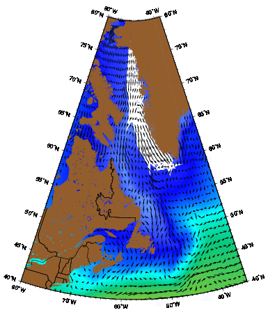
| The West Greenland Current as represented by the Mariano Global Surface Velocity Analysis (MGSVA). Its source water is primarily from the East Greenland Current, and it feeds the Labrador current. The West Greenland Current is an important component of the North Atlantic subpolar gyre. Click here for example plots of seasonal averages. | ||
Cuny et al. (2002) used both Eulerian and Lagrangian data to study the WGC. Their Eulerian data showed that the approximate speed for the shallow WGC was 35 cm s-1. It also showed that there were countercurrents with speeds of about 3 cm s-1 offshore the main current. Lagrangian data supported this finding. Five drifters deployed on the WGC were traveling northwestward when they left the boundary current and moved southeastward. The drifters changed directions at different times and at different places between 59° and 61°N. After staying in the countercurrents for a few days, the drifters began heading toward the interior of the Labrador Sea. Cuny et al. did not observe a complete recirculation loop in any of the drifter trajectories.
Unlike the Eulerian data, the Lagrangian data showed that the maximum speed for the WGC at Cape Desolation is 95 cm s-1 at the 2000-m isobath. The current is slower on either side of the 2000-m isobath; above the shelf, it flows at about 35 cm s-1, and close to the 3000-m isobath it flows at 25 cm s-1. As the water reaches the transition area between the Greenland and Labrador slopes, the current has, on average, half the speed of the shallow WGC. When it reaches the shoaling depths off Greenland, the current bifurcates. Part of the current continues to flow along the Greenland coast, and the rest proceeds westward to join the Labrador Current (Cuny et al. 2002).
The branch of the current that follows the Greenland coast does so until about 75°N. It then crosses Baffin Bay and joins waters from the Canadian Arctic Archipelago to form the southward Baffin Current (Loder et al. 1998; Melling et al. 2001). Thus, the WGC and the Baffin Current form a cyclonic circulation pattern (Melling et al. 2001) that can be seen in hydrographic observations (Muench 1971, Bourke et al. 1989), in the tracks of drifting icebergs and buoys (Fissel et al. 1982; Marko et al. 1982), and in long-term measurements of the currents (Ross 1990a, b, 1991).
The branch of the WGC that joins the Labrador Current has shown the most variability. It is most variable near the shelf break between Greenland and Labrador, due to eddies and/or shelf waves of about 30 km in size that last for several days (Meyers et al. 1989). In addition to eddies, the WGC also exhibits variability in its salinity. Dickson et al. (1984) described a "great salinity anomaly" in the early 1970s. Myers et al. (1989) measured salinity anomalies in the Labrador Sea that were similar in strength to those that Dickson et al. had found, and they concluded that the anomalies apparently occur on a decadal time scale. Variabilities in transport have also been observed. Myers et al. (1989) found that strong winter westerly winds implied weakened shelf break fronts and lower baroclinic transports the following summer. This inverse relationship was consistent throughout the Labrador Sea and may be an important part of the interannual variability of the region.