| ||
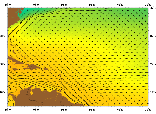
| The Subtropical CC as represented by the Mariano Global Surface Velocity Analysis (MGSVA). Click here for example plots of seasonal averages. | ||
At the height of the colonial era, the Subtropical Counter Current (SCC) was not seen as a unique water mass but considered part of the west-northwest flowing part of the North Atlantic gyre system. The currents in this region usually facilitated the colonial trans-Atlantic trips to the New World, and any interference with the "anomalous" eastward flowing current meant extra anxious days at sea and concern for being ensnared in the expanse of Sargassum weed. Together, the generally still Sargasso Sea waters to the north and the adjacent eastward-flowing SCC region became widely known as The Ship's Graveyard, a legend that continues to resonate in the "Bermuda Triangle" legend of today (Burney, 1912; Halley, 1688; Hanson et al., 1991).
The body of water that we call the SCC here goes by several different names in the literature. Other names used when referring to this region are the (northwest or north Atlantic) subtropical convergence zone, subtropical front or subtropical frontal zone, the Sargasso Sea subtropical frontal zone, and various combinations of these (e.g.s, Böhm, 1988; Halliwell & Cornillon, 1990; Halliwell et. al., 1991; Reid, 1981; Rossby et. al., 1983; Schmitz et. al., 1992).
Most currents in this region have a westward trend but the SCC is an eastward-flowing current, bordering approximately along the southwestern edge of the Sargasso Sea. It is essentially a North Atlantic analog of the eastward subtropical counter currents produced by similar convergent air mass configurations over the Pacific (e.g's.: Li et al., 2002; Nakamura & Kazmin, 2003; Zhurbas & Oh, 2004; also see discussion in Eriksen et. al. 1991). A convergence zone is where two different bodies of water (or air) collide, i.e. converge. The boundary between them is called a front and different physical conditions are found on either side of this boundary.
The convergence or "piling" of water in this region, as well as in regions like this in the Pacific, is caused by a combination of surrounding atmospheric pressure systems, which produce winds that force Ekman transport. The SCC is produced by and thus situated between the eastward-flowing Westerlies in the mid latitudes and the westward-flowing Trade Winds in the tropical latitudes of the North Atlantic. This large-scale wind pattern forces a meridional convergence of Ekman transport because the net movement of water is 90° to the right of the wind direction in the northern hemisphere. This combination of forces also results in some significant downwelling in this region (Hanson et al, 1991). As cold dense water moves southward to the north of the boundary and warm less dense water moves northward to the south of the boundary, a northward pressure gradient in the upper ocean results as well.
Because the air masses that produce the SCC change both seasonally and on interannual time scales, and are unequal in strength, the SCC shifts latitudinally, thus the current is found at a range between about 25°N and 32°N (Halliwell & Cornillon, 1990a,b; Halliwell et al, 1991; Hanson et al, 1991); however, longitudianlly it is generally found between 70°W to about 45°W. At the surface, the SCC is relatively weak, but its eastward flow intensifies with depth, especially at about 26°N (Rossby et. al., 1983). The flow has been observed at 700 m depth, on the average, to move eastward at about 5.3 cm s-1. A slight 0.60 cm s-1 southward tendency was observed, which dissipates at depth to about 0.25 cm s-1 at 2000 m, implying that the meridional flow is more substantial in the upper ocean in this region (Charnock and Businger, 1991; Lee et. al., 1996; Reid, 1978; Rossby et al., 1983).
Westward-propagating eddies, and other wavelike eddy structures with wavelengths of 250-400 km (McWilliams, 1976), as well as some westward recirculation from the Gulf Stream are dominant dynamical features of this region (Böhm, 1988; Eriksen et al, 1991; Halliwell et. al., 1994; Lee, et al., 1996; Olson et al, 1984) that can obscure short-term observations of this weak, eastward-flowing current. Because of the large meridional extent of the current on seasonal and interannual time scales, and the strong eddy field, the mean transport of the SSC is not well-known. Schmitz (1996) estimates about 10 SV of eastward transport by the SCC.
Significant field work on this region was conducted in 1986 during the Frontal Air-Sea Interaction Experiment (FASINEX), which was designed specifically to focus on atmospheric and oceanic dynamics within the vicinity of the persistent westward-moving sea surface temperature (SST) fronts, and how these fronts modify processes of air-sea interaction (Hanson et. al., 1991). Earlier work was done also using satellite imagery by Böhm (1988). This area was chosen for this study particularly because of the well-defined and rather long-lived SST fronts that exist there (WHOI-UOP FASINEX website).
The dynamic processes that operate in this region combine to form the strong temperature fronts that change by 1-3°C over just a few kilometers. The individual temperature fronts in this region can extend over distances of hundreds of kilometers and persist for several months (Böhm, 1988). The region is dominated by zonal bands of strong persistent westward-propagating sea-surface SST anomalies with zonal wavelengths as large as 800 km, lasting about 200 days which are associated with wavelike baroclinic eddies propagating to the west at speeds of 3-4 cm s-1. These speeds are consistant with that expected for first-mode baroclinic Rossby waves east of 71°W (Halliwell et. al., 1991a). To the south and the north of this region, zonal dispersion properties differ substantially resulting in the SST anomalies being effectively confined to the convergence zone and strongly coupled to the baroclinic eddies (Halliwell et al, 1991b).
Because the meridional direction of convergent flow is nearly perpendicular to the mean surface isotherms, the wind pattern acts to increase the magnitude of sea surface temperature (SST) gradients (Hanson et al., 1991). Although distinct westward-propagating fronts of SST with high gradients are a persistent feature in this region (Halliwell & Cornillon, 1989, 1990a,b; Halliwell et al, 1991), there were rarely features on smaller (1 km) scales (Eriksen et al, 1991). The average SST, as determined by Hanson and others (1991), ranges between 26°C in the southern range of the SCC and 23°C at its northern-most expanse. The dominant signal in the annual cycle is a zonally symmetric N-S movement of isotherms. The amplitude of the annual cycle is greater in the northern portion than in the south and implies that the large-scale N-S SST gradient decreases during the summer and increases during the winter. During the summer, the strongest meridional gradients in and around the Sargasso Sea are found north of 30°N, virtually disappearing between 25°N and 30°N (Halliwell et al, 1991; Hanson et al, 1991). Maximum gradients occur in late February and minimum gradients occur in August at the time of the highest SSTs and thus the heating phase is slightly shorter than the cooling phase of the annual cycle (Hanson et al, 1991).
Salinity values range from about 36.50-36.65. In the FASINEX study region, the salinities peaked at the top of the seasonal thermocline and mixed layers were fresher than the stratified layers beneath them, especially on the warmer sides of the front (Eriksen et. al. 1991; Hanson et. al., 1991). Deep isohalines and isotherms tended to be parallel, indicating that little change in water type occurs across the front in the deeper portions of the seasonal thermoclines (Eriksen et al, 1991). Strong surface heating and relatively uniform evaporation in the summer results in a uniform surface salinity and a shallower and far warmer mixed layer than in winter when the mixed layer is at about 100m. In the fall, the winter pattern transition has begun and the salinity minimum shifts southward (Hanson et. al., 1991).