 |
The North Atlantic Current originates between the Grand Banks and Mid Atlantic Ridge near the Newfoundland Ridge at the branch point of the Gulf Stream. Mann (1967, 1972) using a reference level of 2,000 dbar found that the NAC (his "Atlantic Current") was made up of 20 Sv of water from the Gulf Stream and 15 Sv from the Slope Water Current bringing the total transport up to 35 Sv. Other transport estimates for the NAC include 35 Sv (ref leval 1900 m) (Krause et al., 1987); In his figure 15 the Gulf Stream is located at 40°N 50°W and the Slope Water current at 41°N 50°W. Fuglister (1963) considered this to be a typical situation and found a westerly countercurrent separating the two. Rossby (1996) estimates a transport of 40 Sv in his review of the North Atlantic Current. Mann (1967) notes that the currents are permanent but subject to meandering as demonstrated by International Ice Patrol observations.
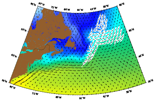
The North Atlantic Current (NAC) as represented by the Mariano Global Surface Velocity Analysis (MGSVA). The NAC transports warm Gulf Stream water poleward. It feeds the Irminger current and the broad northward N. Atlantic drift. Click here for example plots of seasonal averages.
The North Atlantic Current represents the bulk of the Gulf Stream continuation past its branch point. Mann (1967) shows the The North Atlantic Current as comprised of waters from the Slope Water Current and from the Gulf Stream. In his representation approximately 15 Sv are derived from the Slope Water Current with the remaining 20 Sv contributed by the Gulf Stream. The remaining 30 Sv head off to the north east. The NAC is strengthened by mixing interactions of the Gulf Stream and Labrador Current as well. Worthington had shown the NAC as part of a separate Northern gyre, however subsequent work later revealed that this hypothesis was incorrect and that the North Atlantic Current was indeed derived from the Gulf Stream. The North Atlantic Current is generally thought of as the end of the Gulf Stream, however it goes on to feed some of the major subarctic currents completing the poleward transport of tropical waters.
Based on five years of NOAA satellite imagery (1980-1985) Krauss et al. (1987) identified two basic flow patterns for the NAC. The first is the "classical situation" where the NAC flows north past Flemish Cap, into the Northwest Corner (52°N), forms a loop, and turns east. In this case there are only minor extrusions of water on the current's offshore side. The other pattern is the "branching situation". In this case only part of the NAC continues to the northwest corner while large amounts of water are expelled from the eastern side of the current (between pressure cells). Evidence for these different regimes can also be found in hydrographic studies. Worthington (1976) identified and named the Northwest Corner even though he did not show the NAC as a continuation of the Gulf Stream. Krausse et al. (1987) show the NAC branching at 47°N, 41°W with waters from the eastern flank heading northeast and from the western flank heading northwest towards the Northwest Corner.
Clark et al (1980) published one of the most influential reports on this region. They established the branch point proposed by Mann (1967) and refuted Worthington's (1976) two-gyre hypothesis. Clark et al. (1980) found a transport of 53 Sv (2000 dbar reference) for a merged slope water current and Gulf Stream with maximum speeds of ~100 cm s-1. They only found peak velocities of 50 cm s-1 in the North Atlantic Current but noted that they had sectioned the current obliquely. A more typical maximum velocity for the North Atlantic Current is the 100 cm s-1 reported by Krausse et al. (1987). Clarke et al. (1980) found that 26 Sv of the combined Gulf Stream Slope current flow contributed to the North Atlantic Current with the remaining 27 Sv turning east. Although Mann (1967) too had noted the presence of a large clockwise eddy, he had not accounted for its contribution to the northward flow. Clark et al estimated a contribution of approximately 18 Sv (2000 db reference) from this "Newfoundland Basin eddy". The Labrador Current recirculation was shown "blending" into the North Atlantic Current although there was no estimate of transport contribution. Krauss et al. (1990) found that extensive mixing between Labrador Current and North Atlantic Current water produces caballing which too in turn strengthens the North Atlantic Current.
Worthington's two gyre hypothesis is the most influential rejection of the North Atlantic Current as an extension of the Gulf Stream (Wothington, 1962, 1976). Based on the higher oxygen content of waters off Flemish Cap Worthington concocted a new circulation scheme involving a separate northern geostrophic anticyclonic gyre in which the North Atlantic Current functioned as a western boundary current. He also felt that salinity differences between the regions were too great to be accounted for by mixing and used that as further evidence for this gyre. Lastly he cited the presence of a low pressure trough separating the gyres although his flow lines did not correspond well to dynamic height charts. Since so many other aspects of Wothington's circulation scheme were correct his theory was probably given credence for far longer than warranted. The two gyre hypothesis was finally laid to rest by Clark et al (1980) who were able to account for most of the water property differences which initially led Worthington to propose his two gyre theory. They also cited Wothington's departure from geostrophy as major flaw in the theory. Clarke et. al. (1980) confirmed Mann's findings which are that the Gulf Stream splits south of the Grand Banks and that the North Atlantic Current is a continuation of the Gulf Stream.
The other branch of the Gulf Stream was seen as a broad indefinite flow with part returning southwards contributing to the Gulf Stream recirculation (Clarke et al, 1980) and part turning eastward to eventually coalesce and strengthen forming the Azores Current (Klein and Seidler, 1989). During winter months Klein and Seidler (1989) showed a single current flowing from the source region near the Southeast Newfoundland Rise. However, the situation differed in the summer where they found the current from the source region branching into two current bands near 41°N 47°W. The northern branch was found to head almost straight for the Azores Current but the southern branch formed a cyclonic loop with only 70% of its flow crossing the Mid Atlantic Ridge. This may be evidence of seasonality in the source region or may result from the general variability inherent in the source region.
ReferencesClarke et al., 1980: Current system south and east of the Grand Banks of Newfoundland, Journal of Physical Oceanography, 10, 25-65.
Fuglister, F.G., 1963: Gulf Stream at 60, Progress in Oceanography, 1, 265-373.
Klein, B. et al. and G. Seidler, 1989: On the origen of the Azores current, Journal of Geophysical Research, 94, 4905-4012.
Krauss, W., E. Fahrbach, A. Aitsam, J. Elken, and P. Koske, 1987: The North Atlantic Current and its associated eddy field southeast of Flemish Cap. Deep-Sea Research, 34, 1163-1185.
Krauss, W., R. Doscher, A. Lehmann, and T. Viehoff, 1990: On eddy scales in the eastern and northern North Atlantic Ocean as a function of latitude. Journal of Geophysical Research, 95, 18049-18056.
Mann C.R., 1967: The termination of the Gulf Stream and the beginning of the North Atlantic Current, Deep-Sea Research, 14, 337-359.
Mann, C.R., 1972: A review of the branching of the Gulf Stream System, Proc. R. Soc. Edinb., B72, 341-349.
Rossby, T., 1996: The North Atlantic Current and surrounding waters: At the crossroads. Reviews of Geophysics, 34, 463-481.
Worthington, L.V., 1962: Evidence for a two gyre circulation system in the North Atlantic, Deep-Sea Research, 9, 51-67.
Worthington, L.V., 1976: On the North Atlantic circulation, Oceanographic Studies, The John Hopkins University, Baltimore, MD, 6, 1-110.