| ||
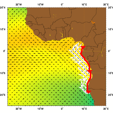
| The Angola current as represented by the Mariano Global Surface Velocity Analysis (MGSVA). The velocity estimates from the MGSVA were calculated at a resolution of one degree of longitude and latitude and it does not resolve the narrow Angola current that hugs the coast. The white arrows highlight the northern flow associated with the Angola-Benguela Frontal Zone and the northerly flow of the Benguela Current. Click here for example plots of seasonal averages. | ||
It took fifteen years of effort, from the time he started his work in Sagres, for Prince Henry to succeed in getting anyone to sail even beyond Cape Bojador (the west African promontory), which was accomplished by Gil Eanes in 1433. Further advances along the African coast were slow-going because of limits in ship design and lost records. It took another 50 years before a Portuguese ship sailed around Cape of Good Hope in 1486 (see Agulhas Current). It is difficult to set an exact date when the first Europeans sailed the Angola Current. Angola itself wasn't colonized until 1575 when the Portuguese settled the coastal town of Luanda, to participate in the slave trade that would help supply the labor force for the growing sugar colonies of the Americas (Peterson et al, 1996; Richardson, 1998; Steinberg, 2001).
In 1960, researchers on the AtlantNIRO expedition detected a water flow along the shelf of southwest Africa. They measured its velocity on the shelf from 17 to 24°S and found that it flowed southward at 5-34 cm s-1. Thus, they named it the South Current (Kuderskiy 1964 as cited in Moroshkin et al. 1970). Ten years later, Moroshkin et al. (1970) wrote about the South Current, saying "In our opinion, this term is unfortunate, since it indicates only the direction of water transport and does not reflect the geographic position of this phenomenon...Angola Current would be a better name, since it follows the coast of Angola over a long distance and reaches its highest intensity there." Most people seem to agree, for this is the name of the current today.
The Angola Current forms the eastern section of a large, cyclonic gyre in the Gulf of Guinea. In the upper layer (0-100 m), it seems to be formed mainly by the southeast branch of the South Equatorial Countercurrent and the southward-turning waters from the north branch of the Benguela Current. The influx of waters originating north of the equator is only moderate. However, in layers deeper than 100 m, northern waters become more important in feeding the Angola Current (Moroshkin et al. 1970).
Moroshkin et al. (1970) described the Angola Current as a fast, narrow, and stable flow that reaches 250-300 m depths and covers both the shelf regions and the continental slope. They measured the water velocity at the surface from 9°S-16°S along the coast and found it to be 50 cm s-1. At 25 m, it was greater than 70 cm s-1. Dias (1983a, 1983b) also measured the current velocity, but on two different occasions. In March, at the surface, the velocity was on the order of 50 cm s-1. At 100 m, it was 70 cm s-1. These results agreed with those of Moroshkin et al. (1970). However, in July, at the surface, the current velocity was less than 42 cm s-1. At 100 m, the average velocity decreases even more, down to 33 cm s-1 (Dias 1983b). These results suggest that there is temporal variability in the velocity of the current. At 200-300 m there is a 5-8 cm s-1 southward flow along the edge of the shelf and over the continental slope. This water may be a deep extension of the Angola Current (Moroshkin et al. 1970).
The volume transport of the Angola Current above 400 m relative to the 800-db level across a profile at 12°S, 9°E has been measured between standard stations at a depth of 500 m. In September 1970 it was 3.7 Sv, and in March 1971 it was 2.6 Sv (Dias 1983a).
According to Lass et al. (2000), Angola Current water usually has a temperature greater than 24°C and a salinity of more than 36.4 psu in the upper mixed layer. This water mass gradually becomes colder and less saline as it travels south (Lass et al. 2000). During winter and spring, the hot Angola Current water, with temperatures between 27 and 30°C, retreats to the northwest and is replaced by slightly cooler waters with temperatures between 20 and 26°C. This periodic southeast advance and northwest retreat of the Angola Current seems to be linked to the intensity of upwelling that occurs later off the Namibian coast (Meeuwis and Lutjeharms 1990, O'Toole 1980).
At approximately 15°S, the southward-flowing Angola Current converges with the northward-flowing Benguela Current to form the Angola-Benguela Front (ABF) (Meeuwis and Lutjeharms 1990). The ABF demarcates the warm, nutrient-poor Angola Current water and the cold, nutrient-rich Benguela Current water, creating a transition zone between the tropical ecosystem in the north and the upwelling-driven ecosystem in the south (Lass et al. 2000). Meeuwis and Lutjeharms (1990) used satellite maps of sea surface temperature to study the ABF in great detail. They found that it is a permanent feature at the sea surface, and that it usually travels from west to east in a series of weak, pulse-like movements that are most clearly defined in the summer and autumn.
In addition, Meeuwis and Lutjeharms (1990) learned a great deal about the dimensions and temperature gradients of the front. According to them, its northern boundary can be found near 14°S and has an average water temperature of 23.6°C. The southern boundary is usually near 16°S and has a temperature of 20.6°C. The position of both boundaries fluctuates slightly. The ABF is typically characterized at the surface by a temperature gradient reaching 4°C per 1° latitude. Average temperature gradients of 1° per 72 km are common, although sharper gradients can be found within 250 km of the coast. Both warm- and cold-core eddies form along the front during the summer, although cold-core eddies are much more common. The front is widest, about 240 km, between the coast and 10°E. However, its width can vary seasonally from 200 km in the winter to 300 km in the summer. On average, the front extends from the coast to 250 km offshore, but it can reach as far east as 1000 km during the spring and summer.
Another feature that can be found near the Angola Current is the Angola Dome, a cyclonic eddy doming of the thermocline centered near 10°S and 9°E (Lass et al. 2000). It was first documented by Mazeika (1967), who studied its shape, location, and thermal distribution. It is a cold water dome that is generated by a local maximum of Ekman suction (McClain and Firestone 1993). The Angola Dome does not exist during the winter (Mazeika 1967), and its width and extension depend on the intensity and horizontal shear of the southeasterly trade winds (Signorini et al. 1999).
The salinity of the water within the Angola dome (35.5 psu) is lower than that of the surrounding water (35.8-36 psu). According to Mazeika (1967), this may be due to vertical mixing of low-salinity Congo River water from the surface layer. The cyclonic circulation of the dome may actually sequester Congo water. Mazeika (1967) also found that the dome had relatively low concentrations of oxygen, even in shallow waters, and reasoned that this may be related to upwelling and biological activity.