| ||
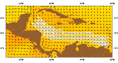
| The Caribbean current as represented by the Mariano Global Surface Velocity Analysis (MGSVA). The Caribbean Current transports significant amounts of water northwestward through the Caribbean Sea and into the Gulf of Mexico, via the Yucatan Current. The source water for the Caribbean Current is from the equatorial Atlantic Ocean via the North Equatorial, North Brazil, and Guiana Currents. The counter-clockwise circulation of the Columbia-Panama Gyre is evident off-shore of southern Central America (Nicaragua, Costa Rica, and Panama) and northern Colombia. Click here for example plots of seasonal averages. | ||
The historical hydrographic surveys of Wust (1964) and Gordon (1967), along with the observations and numerical models of Johns et al. (2002), indicate that water flows into the Caribbean Sea mostly through the Grenada, St. Vincent, and St. Lucia Passages in the southeast. The water then continues westward as the Caribbean Current, the main surface circulation in the Caribbean Sea (Wust 1964; Gordon 1967; Roemich 1981; Hernandez-Guerra and Joyce 2000). The strongest flow in the Caribbean is found across the southern third of the sea and belongs to the Caribbean Current (Gordon 1967; Kinder 1983). In this area, the highest surface velocities can reach 70 cm s-1 along the coasts of Venezuela and the Netherland Antilles (Fratantoni 2001). There are also strong (60 cm s-1) currents along the Panamanian and Colombian coasts, but there is little flow over the Central American Rise, since most of the northwestward flow gets channeled through a trough southwest of Jamaica. The flow turns sharply westward as it crosses the Cayman Basin, and it enters the Gulf of Mexico as a narrow boundary current that hugs the Yucatan Peninsula (Fratantoni 2001). This Yucatan Current flows into the Gulf of Mexico through the Yucatan Channel. It eventually separates from the Campeche Bank and becomes the Loop Current. The Loop Current then becomes the Florida Current as it exits the Gulf of Mexico through the Straits of Florida (Molinari and Morrison 1998). The overall speed of the water as it travels from Aves Ridge to the Florida Straits was estimated by Morrison and Smith (1990). They detected a transport maximum in the Florida Straits approximately 90-100 days after detecting a transport maximum in the eastern Caribbean. Thus, the calculated propagation speed is about 30-40 cm s-1, depending upon the path and mean current speed between Aves Ridge (65°W) and the Florida Straits.
Roemich (1981) described the inflow of water into the eastern Caribbean as three or four westward streams separated by eastward counterflows. As they traveled west, the bands merged into two flows and eventually into one. He cautioned, though, that this interpretation of his data could be incorrect because the spacing between his sampling stations was irregular. Morrison and Nowlin (1982) later suggested that the eastward streams may be permanent features. However, this hypothesis was inconsistent with the trajectories of satellite-tracked drifters, which had net westward movement (Molinari et al. 1981; Kinder 1983). Morrison and Smith (1990) also found eastward flows across the Aves Ridge, and they hypothesized that perhaps the drifters had simply not stayed in regions of divergent eastward flow but had become entrained in convergent westward flows. However, as part of the World Ocean Circulation Experiment, Joyce et al. (2001) carried out a hydrographic section along 66°W in the North Atlantic in 1997, and they did not find the eastward bands of flow that Morrison and Smith (1990) had detected. Instead, they found that the flow in the upper layers of the Caribbean was westward everywhere except along the coast of Venezuela.
Based on the observations of Pillsbury (1891), Model (1950) provided the first description of the inflow through all of the Caribbean passages. He found that of the 28 Sv flowing into the Caribbean, 24 Sv flowed in through the Lesser Antilles passages. Of these 24 Sv, about 18 Sv flowed through the Leeward Island passages and the remaining 6 Sv through the Windward Island passages. As Johns et al. (2002) point out, though, Model's conclusions may have been incorrect because his data was limited; for instance, although Model found negligible flow through the Grenada and Windward Passages, it was later found that these are major inflow channels. Later studies also suggested that, if mass is to be conserved, the inflow from the Atlantic through the Antilles passages should add up to 30 Sv (with a superimposed annual cycle of ±3 Sv), which is the mean volume of water exiting the Gulf of Mexico through the Florida Current (Niiler and Richardson 1973; Schott et al. 1988; Johns et al. 2002). However, some of the studies that sampled the transport through individual passages in the eastern Caribbean (Metcalf 1976; Stalcup and Metcalf 1972; and Brooks 1978) were relatively short and affected by significant tidal and synoptic variability (Johns et al. 2002). Thus, there has been considerable debate over the actual amount of water transported into the Caribbean through different areas.
Gordon (1967) obtained geostrophic transports of 26-33 Sv through the eastern Caribbean and less than 5 Sv of inflow through Windward Passage. Stalcup and Metcalf (1972) found a transport of 25 Sv through the Windward Island passages in March-April 1970. This suggested that most of the water entered the Caribbean through the southern Lesser Antilles passages (Johns et al. 2002). Worthington (1976), on the other hand, estimated 20 Sv through the Caribbean and 10 Sv through Windward Passage. Still another estimate came from Roemich (1981), who used inverse calculations to find a transport of about 22 Sv through Windward Passage (Johns et al. 2002). After reanalyzing the Stalcup and Metcalf (1972) data, Schmitz and Richardson (1991) concluded that 22 Sv of the Florida Current transport came from the southern Lesser Antilles passages, while 7 Sv could be attributed to Windward Passage further north (Johns et al. 2002). Johns et al. (2002) found that the 28 Sv of water flowing into the Caribbean Sea is roughly divided into thirds among the Windward Island passages south of Martinique (~10 Sv), the Leeward Islands passages between Martinique and the Virgin Islands (~8 Sv), and the Greater Antilles passages between Puerto Rico and Cuba (~10 Sv). The Grenada Passage contributes ~6 Sv and Windward Passage contributes ~7 Sv. After reviewing the available observations, they concluded that the area most in need of study is Windward Passage, since estimates there ranged from 3 to 9 Sv.
The Guiana Current enters the Caribbean along the northern coast of South America. The current is significantly influenced by freshwater discharges from the Amazon and Orinoco Rivers (Morrison and Smith 1990). In fact, the Amazon River is the largest point source of fresh water entering the ocean, adding anywhere from 0.12 Sv to 0.25 Sv of water in an enormous surface plume that extends hundreds of kilometers to the northwest (Baumgartner and Reiche 1975; Muller-Krager et al. 1988; Limeburner et al. 1995). Thus, the possibility exists for the variability in riverine contributions to affect the regional circulation (Morrison and Smith 1990). In support of this view, most of the drifters that Limeburner et al. (1995) deployed near the river mouth throughout the year eventually moved toward the Caribbean within 1-6 months.
Water masses entering the Caribbean originate in both the North Atlantic and the South Atlantic Ocean. The origin of the water can be determined by examining its unique temperature, salinity, and dissolved oxygen signature; South Atlantic waters are less saline and have more dissolved oxygen than do North Atlantic waters of the same density (Wilson 1997). The circulation pattern of the North Atlantic gyre suggests that South Atlantic water is likely to enter the Caribbean mostly through the southern passages. Wust (1964) analyzed historical hydrographic data and found this to be the case, but more recent surveys through the southern passages found waters of North Atlantic origin (Mazeika et al. 1980; Wilson 1997). This suggests that the amount of South Atlantic water flowing into the Caribbean may have a strong time dependence (Wilson 1997).
Roemmich (1981) studied the amounts of water leaving the western Caribbean and the amounts of water entering through the eastern Caribbean and the Windward Passage. He showed that the 17 Sv of warm surface water (>17°C) leaving the Caribbean are composed of 12 Sv from the eastern Caribbean and 5 Sv from the Windward Passage. The two thermocline layers, made up of 7-12°C water and 12-17°C water, each have 5 Sv coming in from the eastern Caribbean and 1 Sv from the Windward Passage. Roemmich found no water colder than 7°C. Based on another study of the area, Schmitz (1991) found that the total South Atlantic inflow is 13 Sv; 5 Sv are in the 7-12°C range, 0.8 Sv are in the 12-24° range, and 7.1 Sv are warmer than 24°C. As for North Atlantic water, Schmitz found 1 Sv of 7-12°C water, 13 Sv of 12-24°C water, and 1.8 Sv of water warmer than 24°C for a total of 16 Sv.
Hernandez-Guerra and Joyce (2000) sampled the water masses along 66°W from August to September 1997. They found different water masses in two sections: from Venezuela to about 13°N and from 14°N to Puerto Rico. From Venezuela to 13°N they found a low-salinity water mass that originated in the tropics and South Atlantic. Within the southernmost portion of this area, they observed two different flow patterns. At the surface, there was an intensified westward jet with velocities of 130 cm/s in midbasin. Underneath this flow, there was an eastward flow with a subsurface maximum near the coast of Venezuela. From 14°N to Puerto Rico, Hernandez-Guerra and Joyce found Caribbean Surface Water and Subtropcial UnderWater. Caribbean Surface Water is found in the upper 50 m of the water column. It is relatively fresh, with salinity values of <35.5, and has potential temperature of about 28°C. Caribbean Surface Water is probably a mixture of North Atlantic surface waters, Amazon River water, and local freshwater runoff from South America. Subtropical UnderWater is found deeper, at about 150 m. It is more saline (salinity of 37 or higher) and cooler (temperature of 22-23°C). This water mass is formed in the central tropical Atlantic, where evaporation exceeds precipitation.
The circulation in the Caribbean experiences much variation in both space and time, some of it in the form of mesoscale eddies and meanders. Researchers have proposed several physical processes to explain this variation. Dominant processes depend on bottom topography, wind forcing, current width and shear, and the collision of North Brazil Current rings with the Antilles. Molinari et al. (1981) noticed that most of the eddies or large meanders that appeared in their drifter tracks occurred near large underwater topographic features such as the Aves Ridge (64°W), the Beata Ridge (72°W), or the Central American Rise (82°W). They proposed that these features caused perturbations in the flow when the westward currents passed over them, much in the same way that the New England Seamounts have an impact on the Gulf Stream (Fratantoni 2001). As Kinder (1983) stated, though, "any meander or eddy in the Caribbean is likely to be either upstream or downstream of a ridge," so "the correlation noted by them may have been fortuitous." Kinder also recalled a study by Heburn et al. (1982) in which a numerical model found that eddies probably form near the Aves Ridge independently of the bottom topography.
Wind forcing is another mechanism that has been proposed for causing the mesoscale variability seen in drifters in the Caribbean. However, Kinder (1983) provides two arguments against it. First, that the shallow drifters of Molinari et al. (1981) and the deep drifters of NORDA (Naval Ocean Research and Development Activity, Heburn et al. 1982) behaved similarly. If the wind was an important factor, it should have affected the shallow drifters more than the deep ones. Second, that Heburn et al. (1982) were able to use a model without wind forcing to replicate the behavior of drifters in the southern Caribbean. Kinder speculated that although wind forcing probably modifies mesoscale variability, it is not the primary cause of it.
The tracks followed by the buoys that Kinder (1983) deployed vary in the scales of the mesoscale variability they encountered. In the eastern Caribbean, eddies and meanders were about 100 km wide; in the northwest Caribbean, between Jamaica and Cuba, they were 100-200 km wide; and in the western Caribbean they were 200-500 km wide. According to Kinder, a possible explanation for this pattern may be that the size of the meanders and eddies is determined by the width of the current of origin. In the southeastern Caribbean, the narrow passages of the Lesser Antilles constrain the current width and so the eddies are smallest. In the northwestern Caribbean, the wider Windward Passage and the channel between Jamaica and Cuba do not limit the current as much, and the eddies are larger. Finally, in the southwestern Caribbean, there are no geographical limitations to the Caribbean Current, so it is wide and its eddies are largest.
The most recent explanation for the mesoscale variation found in the Caribbean Sea involves North Brazil Current rings. Johns et al. (1990) related mesoscale variability to "eddy waves", which occur when anticyclonic rings from the Brazil Current collide with the Lesser Antilles Passages (Fratantoni et al. 1995; Andrade and Barton 2000). The ring fragments drift westward into the Caribbean, resulting in mesoscale eddies and meanders with diameters of 100-500 km that travel along the Caribbean Current axis (Fu and Holt 1983; Andrade and Barton 2000; Fratantoni 2001). Lagrangian observations, such as those of Fratantoni and Richardson (1999), support this idea. In addition, Murphy et al. (1999) studied the connectivity of mesoscale variability in the Atlantic Ocean, Caribbean Sea, and the Gulf of Mexico with the aid of three simulations by the Naval Research Laboratory's Global Ocean Model. They concluded that eddies form in the Caribbean partly due to potential vorticity that is advected by the North Brazil Current rings through the Lesser Antilles. Most of the Caribbean eddies are anticyclonic and travel westward through a narrow corridor with an average speed of 15 cm s-1 (Murphy et al. 1999), although they have been observed traveling westward through the northern Caribbean at speeds up to 30 cm s-1 (Nyusten and Andrade 1993; Andrade and Barton 2000). Thus, a 10-moth journey from the Lesser Antilles to the Yucatan Channel is typical for most eddies (Murphy et al. 1999). Based on TOPEX/POSEIDON altimetry and a 1/6° Atlantic Ocean model simulation, Carton and Chao (1999) also concluded that North Brazil Current rings were a source for anticyclonic eddies in the Caribbean Sea, and that these eddies grow as they travel westward, suggesting that the Caribbean Current itself is unstable.
In the area off Panama known as the Gulf of Mosquitos (82°W), Molinari et al. (1981) found a clockwise circulation that contrasted with Wust's (1964) description of a counterclockwise flow, but drifting buoys deployed by Kinder (1983) clearly showed a counterclockwise circulation in this area. Therefore, Kinder suggested that although eddies often appear in the Gulf of Mosquitos, a shallow, permanent gyre does not exist. However, large, semi-permanent circulation features do exist in other parts of the Caribbean.
Nyusten and Andrade (1993) were interested in a cyclonic eddy that appeared persistently, but with seasonal variations in intensity, in the southwestern Colombian Basin in the global eddy resolving circulation model of Thompson et al. (1992). Nyusten and Andrade used altimetry data collected during 1987-1988 to study this area of the Caribbean. Their data showed anticyclonic features that appeared near the Beata Rise (73°W) and traveled westward into the Colombian Basin at an average speed of 15 cm s-1. Because this is significantly slower than the speed of the Lagrangian drifters of Molinari et al. (1981) and Kinder (1983), Nyusten and Andrade suggested that the features were interacting with the mean Caribbean Current, not being passively advected by it. Nyusten and Andrade also frequently detected the cyclonic eddy in the southwestern Colombian Basin during both years of their study. They concluded that this must be a quasi-permanent circulation feature that occasionally changes in position or strength, since a truly permanent feature would have been invisible to the altimeter satellite after the geoid removal technique was applied. Although Molinari et al. (1981), Kinder et al. (1985), and Morrison and Smith (1990) reported mesoscale features in the eastern Caribbean, Nyusten and Andrade (1993) did not detect any. This was to be expected after using the geoid removal technique and supports the suggestion by Morrison and Smith that the circulation features are quasi-permanent.
Mooers and Maul (1998) ran numerical simulations in which a broad cyclonic circulation appeared between Panama and Colombia in the Gulf of Darien (77°W). They called this the Panama-Colombia Gyre. Upon closer inspection, it was evident that the gyre was actually made up of an intense cyclone flanked by an anticyclone and cyclone, all embedded in the larger, weaker cyclonic circulation (Andrade and Barton 2000). However, although Andrade and Barton (2000) also observed a broad cyclonic circulation that advected eddies in this region, they did not find the triad of eddies that Mooers and Maul (1998) had described.