| ||
| The Slope Jet current as represented by the Mariano Global Surface Velocity Analysis (MGSVA). Click here for example plots of seasonal averages. | ||
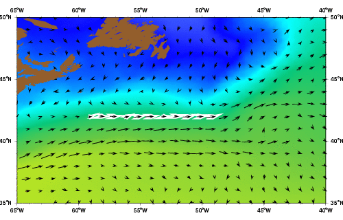
The SJ is partly fed by the Gulf Stream, which bifurcates in the vicinity of the New England Seamount Chain (NESC), and by cooler, less salty Slopewater. The Slopewater is a mixture of water from the Labrador Current and coastal water from inshore of the continental shelf. The SJ current region is a narrow area, about 250 km wide, that lies above the continental slope between Cape Hatteras and the Grand Banks, and is bounded to its north by the continental shelf and to its south by the northern edge of the Gulf Stream. This region's dynamics are further complicated by its setting as a confluence zone for subtropical and sub-polar waters (Haza, 2004; Pickert et. al. 1999). Circulation near the Grand Banks is remarkably complex, consisting of a series of wind-driven currents extending from the shelf-break to the deep slope (Pickart et al 1999).
The SJ water has been suggested by McLellan (1957) to be a mixture of 20-50% coastal shelf waters and 50-80% Gulf Stream water. The average sea surface temperature of the SJ ranges from 17°C to 19.5°C and the salinity ranges from 34.4 to 35.2 psu. The transition between these three adjacent water masses consists of sharp temperature and salinity gradients, which are visible from sea-surface temperature data and hydrographic surveys. One of the characteristics of the strong temperature front that marks the transition between shelf and slope waters is its coincidence with the path of an eastward current flowing parallel to, and north of the Gulf Stream in the upper slope waters between 40°N and 43°N.
According to McLellan (1957) about one-fourth of the SJ comes from the inflow of the Labrador Current Water to the Mid-Atlantic Bight, all of which eventually re-circulates and mixes with coastal shelf waters, while the remaining portion originates from the Gulf Stream. Estimates of the transport values of the SJ range from 10 to 20 Sv (McLellan, 1957) with larger transport values eastward. The increase in transport is partly a result of the Gulf Stream water and partly because of the entrainment and mixing of waters from the shelf and from the Labrador Current (LC) flowing from the north. The most recent investigation of the SJ current by Pikart et. al. (1999) comes from hydrographic measurements from a series of cruises that were conducted between 1959 and 1999, and centered around 55°W and 50°W. Their derived transport of the SJ from geostrophic velocities is weaker than McLellan=92s (1957) estimates, with an average of 2-3 Sv at 55°W and 9 Sv at 50°W. This transport estimate is probably biased low because there is only a small number of repeat hydrographic transects in this region in over four decades and the large eddy variability. The large eddy variability is due the presence of Gulf Stream Warm Core Rings and large amplitude meanders of the Gulf Stream Current (see Figure 9 at http://oceancurrents.rsmas.miami.edu/atlantic/atlantic-videos.html).
The SJ position varies laterally with the Gulf Stream at 55°W and its transport varies with the transport of the Labrador Current (as well as with changes in the deeper components of the slopewater) at about 50°W (Haza, 2004; Pickart et al, 1999). Although Pickart (1999) finds that the SJ strength and position spins up and down on inter-annual timescales, coincident with strengthening and weakening of the overflow component of the deep western boundary current, statistical analysis of the outputs of a high resolution numerical model (MICOM) indicate sub-annual to annual timescales for the same type of variability, predominantly at 9-10 month and 1 year timescales (Haza, 2004).