| ||
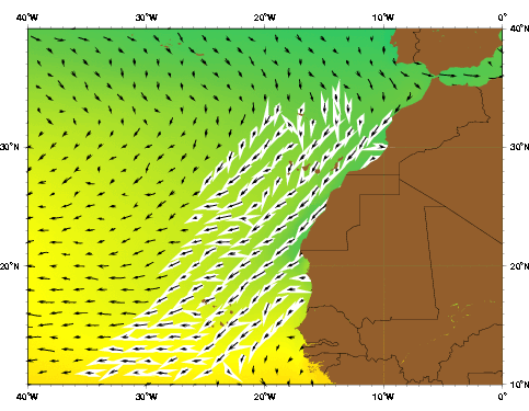
| The Canary current as represented by the Mariano Global Surface Velocity Analysis (MGSVA). The Canary current is the southwestward flow component of the North Atlantic subtropical gyre. The northernmost highlighted velocities are also known as the Portugal Current. Click here for example plots of seasonal averages. | ||
The Canary Current system contains coastal upwelling, filaments, and eddies (Johnson and Stevens 2000). Eddies with length scales of 100 to 300 km form along the coastal boundary of the current (Mittelstaedt 1991).The eddy kinetic energy values for the Canary Current are less than 100 cm2 s2 (Zhou et al. 2000).
A branch of the Azores Current joins the Canary Current along the continental slope between the Madeira Plateau and the Canary Islands (Zhou et al. 2000). Batten et al. (2000), citing Tomczak and Godfrey (1994), state that the Portugal Current, which lies off the Iberian west coast, is actually part of the Canary Current. Other sources, however, distinguish the Portugal Current as a separate current that transports about 3 Sv southward in the upper 800 m (Stramma 1984).
Fedoseev (1970) described the seasonal patterns of the Canary Current based on data collected from 1957-1966 as part of the Atlant-NIRO expedition. During winter the trade winds are at their peak strength, and so is the Canary Current. Its core velocity can be more than 75 cm s-1 as it passes through the Canary archipelago. It moves parallel to the coastline up to 20°N, forming cyclonic gyres on the shelf along the way. When the current reaches the area of 15°N, it begins to flow west under the influence of the Equatorial Countercurrent. Although the two currents flow in the same direction, they do so at different speeds; this causes two anti-cyclonic gyres to form at the border between them. In spring the Canary Current weakens along with the trade winds, while the Equatorial Countercurrent strengthens. An anti-cyclonic gyre forms to the west of the current. The summer brings about further weakening of the trade winds, and this reduces the water inflow from the north. The Canary Current weakens further and spreads outward from the coast. The cyclonic gyres on the shelf weaken or disappear completely. The Equatorial Countercurrent, on the other hand, is at its peak and shifts north, separating the Canary Current from the coast. During autumn the Canary Current is at its weakest, but some of its characteristics are very similar to those during winter. The current passes through the Canary archipelago, the influence of the Equatorial Countercurrent is the same as in winter, and the strong cyclonic gyres form once again.
Stramma and Siedler (1988) provide a contradictory description. Their geostrophic computations indicated that the Canary Current is weak and variable in the winter and spring. Their one-year record also detected northward flows during November-December 1984, April-May 1985, and September-October 1985.